Tag Archives: nature

The Cobra

I got a phone call this morning from our driver.

Sir, are the children at home?

Yes. Why?

I caught a small cobra over here at SAP and I want to bring it over there to show them.

I suspected another harmless rat snake, because last week he brought a rat snake from the office campus. It was not…

Pic of the Day – The Monster

Somewhere out there in the forests of spider valley is the monster that left this stool behind. And they say that the tiger is the king of the Indian jungle. Not even kitty messes with these things.

In Search of Spider Valley – Part II

Continued from part I

So we were off onto a broken dirt track that supposedly led (in the wrong direction) towards Kempakerai and supposedly would return to blacktop within a few hundred meters. The latter was true and soon we found ourselves climbing a mountainside, deeper and deeper into the jungle. Within a couple of kilometers, we climbed to a ridgeline and came to a fork in the road. There was a stone sign, presumingly giving directions and distances. Unfortunately it was in Tamil and nobody in the car could read the Tamil script, so it was no help. Both directions seemed equally jungly and we were certainly not where we planned to go, so we randomly went left. Within a few minutes, we came to a bridge over a dry riverbed. We parked the car and started exploring up the riverbed.

It was easy walking and we could look for animal tracks if any were to be found. They were to be found in abundance, but were all cows and goats. There might possibly have been deer among them. I find the tracks difficult to discern, but there were at least three types of spoor in the river bed. There were the usual cow patties, the tiny balls usually associated with goats and deer and a third kind. It consisted of small, elongated cylinders, about one centimeter in diameter and three centimeters long. These were in turn woven into logs. I’d seen them before while hiking in the Western Ghats and there were no goats of cows in that area. Might they have been sambar or chital?

Eventually, we stopped and had a lunch of bread and hard boiled eggs brought from home. We were at a bend in the riverbed, just below a peak. As we ate lunch, we watched a small jungle fire slowly spread. We photographed it, listened to its crackle and eventually decided to clear out of that area lest we get caught in a spreading forest fire. That was the first of several such jungle fires we saw. None of them seemed to be in any hurry to start a conflagration the way fires in the Pine Barrens do. We need not have been concerned.

So we went back to the car and made our way back to the work in the road, so that we would not be caught on the wrong side of the ridge if the fire reached there. As the fire was far from the fork, we quickly forgot about it and went to explore the other way. We wound our way down switchbacks with spectacular views of a large valley between two rocky ridge lines. Eventually the way came down to the valley floor and as we drove along, passing tribals collecting sacks and sacks of tamarind. We also started seeing elephant dung. We reached a washed out bridge over a dry river bed (the same creek as before, only downstream) and rather than risking getting the Innova caught in the sand, we stopped there and started exploring the riverbed and the trails in the area. We found the usual signs of domestic animals as well as old, dried up elephant spoor and what appeared to by a deep footprint left when the earth on the riverbank was last soft.

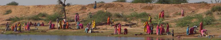
Taking a break back at the car after one of the exploratory forays, we shared our cookes with some villagers heading home after collecting tamarind. They were delighted to have our cookies and the eldest man among them divided them up very carefully, ensuring that every man and woman received the same number of cookies. After they finished, rather than simply tossing the bag aside, they took it with them. Can I infer that tribals don’t litter? If so, I’m delighted. Wrenzo informed us that they had told him that we should not be around after dark as elephants regularly came through there and you never knew what mood they might be in.

We still had time though, so we set out to use our last hour before we had to leave. We followed a trail uphill through the scrub jungle. Sammy was loudly announcing that we were in the scrub jungle and that there were elephants and leopards around; ensuring that there would in fact be no leopards or elephants within a one kilometer radius. Near the top, we saw a group of large, dark, rounded shapes? Elephants or boulders? If they were elephants, they would likely bolt if we approached. If they felt that the young had to be protected, it could turn ugly, so I held the kids at a safe distance while Hanna and the Daniela’s sisters cautiously approached. I brought the kids up when it was determined that they were boulders. We did find lots of dried up spoor in the area of the boulders. There were no recent signs or tracks however, leading me to believe that the pachyderms have moved to wetter areas –possibly to the banks of the Cauvery – for the dry season.

We also found large, ground based spider webs everywhere. Notably, they seemed strewn and clumped among the rocks of the riverbed as well; seemingly washed there. Given that the riverbed has been dry for weeks or months, this is a testament to the durability of the spiders’ work.

When we got back to the car, Wrenzo informed us that some of the jungle dwellers had told him that there was one lone elephant in the area with an injury. It was ill tempered and had overturned a vehicle a couple of days earlier. I’m not certain about the authenticity to embellishment ratio of the story was (especially given that the signs of elephant activity were old), but I’m certainly glad that we did not see any lone, irritable elephants.

Reluctantly, we returned to Bangalore. This is exactly the kind of place that I had been looking for this past year and I’ve already started formulating plans for the next trip. Interestingly, during the trip, I recorded our various places in my GPS. It is a Garmin Forerunner and not really intended for navigation, but rather as an advanced training device. It is a useful tool for marking locations and recording paths. After arriving home, I put them into Google Earth to see just how far off we were and what landmarks we should keep an eye out for next time. I now believe that we were actually in “spider valley”.

Astonishingly, we ate lunch a mere mile downstream from Kempakerai. Had we continued up the river bed, instead of turning back due to the jungle fire, we’d have shortly reached Kempakerai. Had we driven another few minutes instead of stopping at the bridge, we’d have reached the same by road. The directions had been correct; despite not mentioning the fork in the road. We had thought that we were north of where we were, on the main Anchetti-Pennagaram road, when in fact we were south of that on a road that was not on the map. Where we parked the car the second time was about 4km from the banks of the Chinar river and a mere 12km from Hogenakal Falls as the crow flies. The other option for spider valley has a road running through it. The valley we were in has a paved road, but it is only a single lane track; not a proper road and it seems to fit Anderson’s description quite well..

In any case, I plan to return.

In Search of Spider Valley – Part I

I’ve been reading a lot of Kenneth Anderson lately. He was originally a big game hunter who worked in the middle decades of the 20th century in South India. He made his name hunting down numerous maneaters (both leopards and tigers), as well as the odd rogue elephant and people-killing bear. In his later years, he became a writer and a conservationist. He had a slightly earlier and better known counterpart who followed a similar track; a man Jim Corbett, who now has a tiger reserve named after him at the foot of the Himalayas. Corbett concentrated on North India and Anderson concentrated on the south; mostly places within a 200 mile radius of his home in Bangalore. Anderson serves as an inspiration to South Indian nature lovers and conservationists. In fact, there is a local conservation group named after him; which reminds me that I’ve had a sealed envelope with my membership application sitting on my desk for a month and need to call the courier service.

A considerable part of his writing involves an area of Northeastern Tamil Nadu, north of the Cauvery River and especially an area he calls Spider Valley. Hanna mentioned that she’d like to do a bit more hiking before heading back to Germany. As I’d already been scouring maps, Google Earth, finding it on wikimapia.org and going through a blog post about a recent hike there, I suggested that we try to find this place. I say “try to find” as Anderson wrote forty years ago about events a decade or two prior to that. In addition, he was often coy about describing exact locations for fear of them being stampeded.

So we set out from Bangalore yesterday morning with the objective of finding either the village Kempakerai or Kodekerai, both of which are repeatedly mentioned in Anderson’swritings. The general idea was to find one of the villages, find a local willing to work as a guide and then hike a bit; or just wander off into the woods as we saw fit.

Within an hour and a half, we had reached Denkanikotta. After that, we entered the hill country and it became very jungly. Along the way, we were lucky and spotted a crested hawk eagle sitting in her nest near the roadside. Things looked promising.

Nested Hawk Eagle

Nested Hawk Eagle

After subjecting the poor raptor to the paparazzi treatment (though we used a telephoto lens so that we could keep our distance), we continued on our merry way. Getting as far as Anchetti was easy enough after that, the directions from the villagers became vague; often with half the men in a hamlet turning out to debate the proper way to go. Eventually, at one hamlet, we were told to turn onto a dirt track and that Kempakerai would be a few kilometers up the track. We were also informed that the rough dirt track would turn into clean blacktop soon after leaving the village. The only catch was that it led to the left. If we were following the road from Anchetti towards Pennagaram, these two villages should have been on our right. Such is finding your way in India.

Foreigners are not allowed to have Survey of India topographical maps, so we have to rely on Google and asking for directions. This is a pity as that region has not changed much in the past half century and I have excellent orienteering skills with a map and compass. Given our past experiences with “I don’t actually know the way, but I don’t want to say so. So I’ll just give directions based on my best guess”, I resigned myself to not finding spider valley that trip. I presumed the track to lead off towards the North side of the Anchetti-Pennagaram road and thought that in any case, we’d find a nice place to do some hiking and with a little luck, we might even come across the forest department’s Aiyur rest house; where we might be able to find more reliable information.

So we followed the track.

To be continued.

Pic of the Day – Raptor Row

This is another Jaipur photo. I saw a group of black kites lines up on a rooftop in the early morning light and just had to take a shot. One thing that India has is an amazing number of birds of prey. In America, eagles are associated with wilderness. Here, I’ve seen at least two different breeds (booted eagle and short toed snake eagle) in Bangalore. And then there are the kites. They are everywhere. I think that they fill the same niche as seagulls do in other places as they are mostly scavengers and are more common in cities than the countryside. One thing that defines cities in India is the swarms of big raptors turning, twisting and soaring overhead.

Raptor Row

Raptor Row

Pic of the Day – The Scorpion

A scorpion that we ran into while hiking at Skandagiri two weekends ago. The little bugger was about 6″ (15cm) long. I have no idea what species it was or just how poisonous it was (or was not). The shot was taken by Siva’s husband, Horst.

Scorpion

Scorpion

Indiana Joneses

We took a day trip to Krishnagiri this past weekend. It is a town in Tamil Nadu, about an hour and a half east of Bangalore. It’s main claim to fame seems to be that is sits at a road junction between the superhighway to Chennai on the coast and the half built superhighway heading towards points south.

Lonely Planet does not mention Krishnagiri; not even an “overlooked gem” mention, which Tiruvannamalai gets. They don’t seem to get many visitors there; especially westerners. For example, when I stepped into a shop to see about buying a cola (you can buy Coca Cola and Pepsi in the remotest corners of the world it seems), the elderly proprietor –who was Muslim judging by his white skullcap, knee length white kurda, the fact that an Urdu girls school was across the street and there were women in Burkas on the street – stared at me, slack-jawed. I felt like I was in the presence of an Islamic Gomer Pyle. He did not know any English and I was wondering if going to fetch Siva from the car to have a Tamil speaker present would help. This seemed to be an Urdu speaking pocket and I’m not even sure this guy could speak Tamil. Fortunately, his middle-aged son was not so stunned by the sudden appearance of the green antennaed alien in sunglasses. I asked him if he had cola.

No Coca Cola, only Sprite. You want?

I demurred and bid the slack jawed purveyor of Sprite and his son a good day.

Krishnagiri may not be in the guidebooks, but it certainly is at least as nice as Nandi Hills and certainly worthy of a day trip from Bangalore. The town is dominated by a mountain, on the top of which rests the ruins one of Tipu Sultan’s forts. This mountain is in effect a slightly rounded mesa and the old fortifications ring the outer edge of the table top. The rest is scattered ruins set in wild nature. There were hardly any people up there even on a Saturday afternoon; only some kids taking a swim in an old ritual pool from the Sultan’s time and a few Pentecostals singing the praises of Jesus in Tamil. We could picnic and explore to our hearts content.

This being India, there was a shrine on the mountain-top. Krishnagiri being heavily muslim, it was an Islamic shrine. What struck me was how colorful and almost kitsch it was. (no, I did not take my shoes off and step inside, but it was an outdoor shrine overlooked by a giant rock) Somehow, I was expecting something austere and almost Calvanist as the wahhabist variety practiced in the Arabian peninsula largely defines my stereotypes of Islam. I don’t know if it was a Sufi shrine. To my knowledge, Sufism has a lot of mysticsm thrown in; somewhat resembling the Catholicism of Central and South America.

The mountain top was repeatedly visited by a pair of short toed eagles and I think that Sammy and I found a baby monitor lizard. They can theoretically grow to six feet, but as “Iguana” (a local misnomer for the monitor) blood is reputed to have magical healing properties, most don’t live to get any bigger than a couple of feet long. Oh and don’t let them hit you with their tail! It will turn you into a hijra (transvestite); or so our driver once told Daniela.

Oh and did I mention that we did a lot of exploring? I felt like Indiana Jones for most of the time.

Hogenakal Falls

On Sunday, we took a day trip to Hogenakal Falls, on the Karnataka-Tamil Nadu border. It is a three and a half hour drive from our house in Bangalore. In any country but India, I’d regard this as outside of daytrip distance, but the fact that it takes forever to get anywhere has toughened us with regard to out daytrip driving tolerance.

After driving 100 kilometers while dodging ghost driving motorcycles and busses on the superhighway (ummm… guys, you have two lanes demarcated for you just over there ) and a 50 km jaunt through rural Tamil Nadu, the road came to a barrier. We paid twenty rupees road toll and another ten to the forest department and started into the park that houses the falls.

It was almost like being in an American national park. Suddenly there was no traffic, just the road through the mountainous forest, scenic vistas and the odd roadside monkey troop. It was a tropical Smokey Mountain National Park, complete with stone kilometer markers.

Then we arrived in Hogenakal village, at the falls itself.

It was as if someone took a Tamil rendition of Pigeon Forge and instead of thoughtfully leaving it just outside the park’s boundaries, dumped it smack in the middle of the park. Oh and given Indians’ attraction to waterfalls, it was another taste of Athirapilly style mass tourism. Not a foreigner in sight, besides ourselves. Oddly, every second person asked us if we wanted a massage. It turns out that this stretch of the Kaveri River is famous for its healing properties and has become a bit of a domestic spa town.

The falls themselves were magnificent! They are not high. At their highest part, they are only 120 feet high and look to be much less. They are formed where a wide, shallow section of the river is speared head on by a narrow, rocky gorge. This gorge spears a kilometer (about 2/3 mile) into the river as the river collapses into it.

How the falls are laid out

How the falls are laid out

The result is an endless series of falls on both sides. And we were there at the height of the Northeast Monsoon; so the river was an angry white torrent as it crashed into and trough the gorge. We walked around the lower and middle falls and then we and the rest of India took a ride in a coracle – a kind of round canoe – to a small island at the very tip of the falls; perhaps too close in retrospect. But hey, they were definitely worth a visit; despite the distance and the crowds.

Lower Falls

Lower Falls


Middle falls with the upper falls in the distance

Middle falls with the upper falls in the distance


Upper Falls

Upper Falls


Boatman with his coracle

Boatman with his coracle

A little nature

One of our side trips in Kerala was to Athirapilly Falls. It is a 30m (100ft) high waterfall in the foothills of the Western Ghats. It if fabulously gorgeous there; with the waterfall tucked in between hills covered with lush rain forest.

Athirapilly Falls

Athirapilly Falls

This place is not on the usual list of must see places for western tourists, but it is popular with domestic tourists. Despite the backdrop, it is not so much a nature experience as a social experience. Welcome to Indian mass domestic tourism.

The Trailhead at Athirapilly

The Trailhead at Athirapilly

Oh yeah!

First Trek – Part II

Continued from part I

Snakes Seen: 0
Other Animals Seen: 0
Leopards Seen by Sammy: millions (at least)

After starting up the incline, we left our guides behind. The ubiquitous tracks of domestic animals also disappeared, so I guess the cows were not into rough terrain. The kids probably also thought better of actually making the long trek up the hill.

From there on, we saw nobody! Not a single soul was on that mountain, which is pretty amazing for India. We heard small animals in the brush a few times (mongoose? civets? monkeys?), which Sammy always insisted were leopards. Naturally, he “saw” them as well. Daniela was concerned about leopards. The region does have them in abundance. Last year, a school in the outskirts of Bangalore had a family come onto its grounds and another wandered into a shopping complex in Hosur on a Saturday morning, just to the east of where we were. It is hard to estimate how dangerous they could be. I reasoned that they are essentially mountain lions with spots. The two species are the same size, weight, inhabit the same ecological niche and have the same “performance envelope”. Mountain lions – technically being small cats – can purr, while leopards can roar. So we used the protocol for hiking with kids in mountain lion country; no wandering off alone and keep the kids close (no more than 15m/50ft away) and visible. In the future, it might be wise to ask the locals if they have lost domestic animals to leopards recently.

About halfway up, we stopped for a break on a rock overlook, where we relaxed for a while the kids turned themselves into naturalists, studying the local insects and flowers. We debated having lunch there. Eventually, we decided that if we had lunch there, we’d not make it to the top and the top was just a short distance away. In fact, it took over an hour to reach the top from there. As Nitya later said, if we had known how far we were from the top, we’d not have tried it. As it was everyone was glad we did. Tara’s three year old legs gave out and Ram stoically carried her on his shoulders. I also took her for a while to give him a break. It has been a while since I carried a talkative three year old up a mountain on my shoulders. They are heavier than in my idealized memory.

Near the top, we found dung from a large herbivore. There was some debate about whether it was elephant or gaur (Indian bison), but none of us really knew for sure and had left my Indian mammals field guide at home.

On reaching the top, we were treated to the Ranganatha Swamy temple, one of several in the Cavery river basin. This is a small one, built under a gigantic boulder at the top of the mountain. It only operates on Saturdays and is otherwise deserted it seems. We enjoyed the solitude, ate lunch, lounged and explored the temple grounds. Eventually, we took the hint of gathering wind and thunder in the distance as our cue to descend.

When we got back down to the village, we had one last interesting encounter. There was an old woman who had a burning question in her mind; one that must have been bothering her all day.

Why did you go to the Ranganatha Swamy temple on the wrong day? Today is a Laksmi fewstival, not a Ranganatha Swamy festival.

I’ll make a mental to always hike to remote temples on the “wrong” day.